
Spurn Head (The Shivering Sand)
")
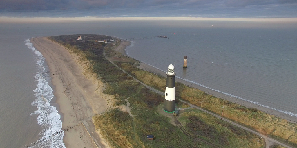
Spurn used to be the most prominent spit—a “narrow coastal land formation that is tied to the coast at one end”—along the Yorkshire coast (Britannica). Extending for around three and a half miles from the mainland, Spurn’s unusual shape and flatness make it a notable geographical feature. However, the difficult conditions presented by such a narrow—at some points only 50 yards wide—and low-lying strip of land meant that Spurn was largely left untouched by human hands. Indeed, the only prominent development pre-WWIwas a very small community of fishermen, coastguards, and lighthouse keepers at Spurn Head—the tip of Spurn. This community primarily operated two seafaring buildings: a lifeboat station, built in 1810, and a number of lighthouses. The history of lighthouses at Spurn Head actually traces back to at least the 15th century. The two lighthouses operated during the early-to-mid 1800s were built in 1767 by John Smeaton; one served as a low light and the other a high light. The high light remained in use until 1895, when it was replaced by a more modern lighthouse, while the low light, due to it being damaged at high tide, was replaced in 1852.
Developments at Spurn Head dramatically increased during the First World War, when Spurn’s strategic position led the British military to build multiple military fortifications, including barracks and a railway track from the mainland to Spurn Head. The military maintained ownership over much of Spurn until the 1950s, when it was sold to the Yorkshire Wildlife Trust. Since then, Spurn has mostly been a public nature conservatory, with historical tours and safaris. In fact, the only dramatic change to Spurn since 1950 was a major tidal surge in 2013, which flooded over the spit and turned Spurn Head into a tidal island. This has made it more difficult to reach Spurn Head, and also invalidated Spurn’s classification as a spit, but the unique environment, wildlife, and topography of Spurn are still open for all to see.
Works Cited
Britannica, The Editors of Encyclopaedia. "Spit". Encyclopedia Britannica, 20 Jul. 1998, https://www.britannica.com/science/spit-coastal-feature. Accessed 28 September 2021.
Elliot, George H. European Light-House Systems: Being a Report of a Tour of Inspection Made in 1873. Lockwood & Co., 1875, pp. 115-116.
“History of Spurn.” Yorkshire Wildlife Trust, www.ywt.org.uk/history-spurn.
Treasure House Archive Maps, treasurehousemaps.eastriding.gov.uk/Maps/MapView?param=OS_1_269.jpg.
“Seven Wonders - Spurn Head.” BBC, BBC, www.bbc.co.uk/england/sevenwonders/yorkshire/spurn/.
“Spurn.” Wikipedia, Wikimedia Foundation, 23 Aug. 2021, en.wikipedia.org/wiki/Spurn.
Parent Map
Coordinates
Longitude: 0.108314200000