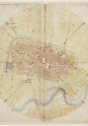
The First Geometric Map
Under the service of Pope Alexander VI’s son, Cesare Borgia, Leonardo Da Vinci was named “General Architect and Engineer”. The Pope wanted a paper visual of the land newly acquired by the Roman armies and wished to improve upon their defense. Thus, Da Vinci joined the troops in Imola and began his expedition there. The map created is believed to be one of the first geometric maps. This differed from medieval maps as it displayed no symbols of religion and displayed the world as accurately as possible according to measurements. However, one can see there are 8 lines protruding from the center of the map, which represent the winds, and within those sections, the map is further divided into 8 more sections. Historians believe this increased accuracy, as Leonardo created the map based on this viewing and measurements from the Palazzo Comunale, in the center of town, and did not have grid lines. What is also impressive is that not only were military details included, such as nearby towns and their distance, but so were older parts of the town. One theory is that Da Vinci based his map on an older map from 1473, thus the details were simply added from it. As far as historians know, this is the oldest map preserved of a town that still exists.
Source: “Leonardo Da Vinci (Vinci 1452-Amboise 1519) - A Map of Imola.” Royal Collection Trust, rct.uk/collection/912284/anbspmap-of-imola.

