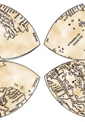
Mapping a New World
With the discovery of the Americas, new world maps had to be drawn and with the knowledge that the Earth is not flat, many cartographers struggled with the representing the continents as they physically were. Da Vinci took a new approach of making 2, 4-leaf clovers next to each other to create the map. For many, this was a revolutionary idea. The Arctic was shown as a sea and the Antarctic was shown as a continent, concepts that were newly discovered at that time as well. Additionally, Da Vinci was the first to use the word America. Most of his depiction was based on information from Amerigo Vespucci. Still, there were some in accuracies in the map as Da Vinci had not perfected the perspective needed. Europe is enlarged to a great degree. Da Vinci’s approach was a step in the right direction however, as the rectangular map was extremely inaccurate at that time, and even today.
Sources:
Chepkemoi, Joyce. “What Was Leonardo's World Map?” WorldAtlas, 5 June 2017, worldatlas.com/articles/what-was-leonardo-s-world-map.html.
“Leonardo Da Vinci's Mappamundi.” ODT Maps, www.odtmaps.com/behind_the_maps/amundi-map-details.asp.

