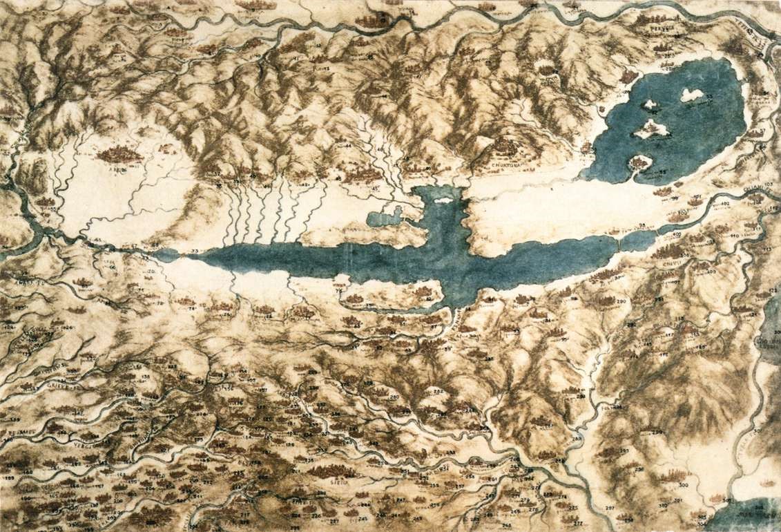
Florence, Italy

Here, Da Vinci did is first works representing space as 3 dimensional and was possibly hired by the city itself to create maps for a canal. As Da Vinci's first home, Florence had a lasting impact on him and the work he did in cartography.

Coordinates

Latitude: 43.769560400000
Longitude: 11.255813600000

Timeline of Events Associated with Florence, Italy

Date Event Manage

Map of Valdichiana Valley

5 Aug 1473 to 5 Aug 1473

The First Work: "La Valle dell'Arno"

The first of his drawings, Da Vinci sketched "La Valle dell'Arno" when he was 21. It is one of the first pieces to show a landscape without any religious symbols or human. With the Renaissance occurring at this time, it only goes to show how daring Da Vinci was in terms of separating the church from the artistic and scientific aspects of life. Instead, viewers see an approximately to scale scene of the Arno Valley and without any elements beings completely distorted to show how God may see the world. This was an essential development as maps at this time were influenced by artists' views and Da Vinci showed that not everything needed to have a relation to God or the church. Additionally, it encouraged the idea that scale can be shown in an image with human viewers in mind, thus there should be a direct relationship between the actual landscape and that drawn.

Source: “Landscape Drawing for Santa Maria Della Neve - by Leonardo Da Vinci.” Leonardodavinci.net, www.leonardodavinci.net/landscape-drawing-for-santa-maria-della-neve.jsp.

https://www.leonardodavinci.net/landscape-drawing-for-santa-maria-della-neve.jsp#prettyPhoto[image1]/0/ La Valle Dell'Arno
circa. 1503 to circa. 1503

Map of Valdichiana Valley

This map was supposedly created when the Da Vinci was still in service of Cesare Borgia. Yet there is evidence that there was little military purpose. While the locations all have names, the rivers are detailed with names as well. Many believe that Da Vinci created the map to build a canal from Florence to the sea. Using the map created, one could plan a dam for Lake Chiana, allowing the canal to be used even during the dry season. Due to this fact, the map seems to serve a more commercial purpose. Alas, it could also be used for transporting soldiers and equipment as well. As the canal was never made, the purpose of the map, or the canal, is not truly known.

Sources:

“Map of Tuscany and the Chiana Valley.” Web Gallery of Art, wga.hu/html_m/l/leonardo/13maps/2tuscany.html.

“A Map of the Valdichiana.” Royal Collection Trust, www.rct.uk/collection/912278/a-map-of-the-valdichiana.

circa. 1515 to circa. 1515

Moving the Arno: An Idealized Florence

Returning to Florence, Da Vinci devised a scheme that would make the city more efficient. The main idea was straightening the Arno, likely to make it more geometrically pleasing to work with. He also added that there would be five total main streets, three running perpendicularly over the river and two running parallel to it. This would make the flow of traffic much more efficient and less confusing as there would be no twist and turns. The city limits would be bordered by a wall in the shape of a 11-sided polygon. On the bottom there are 9 names for the 9 gates Da Vinci added on this map, each at a different street and wall intersection except for one. When taking into account all of the different projects Da Vinci did in his lifetime, one may say that this project connected to his idea of a two-level city. This would only increase efficiency along the main streets. Alas, like many other Da Vinci ideas, this idealized city was never built.

Source: “A Schematised Plan of Florence.” Royal Collection Trust, www.rct.uk/collection/912681/a-schematised-plan-of-florence.